Tuesday, October 22, 2013
Send a Friend a Sunset Thought....Compliments of Lake Clear Lodge
Come stay on the lake, near the woods.... the way the Adirondacks used to be
Monday, October 21, 2013
Paddle Floodwood 2
Paddling Floodwood - Post #2 Clearly Bob
There is a group of beautiful ponds just west of the northern end of Upper Saranac Lake that offer many options for an enjoyable day's paddle. This area is just south of the St Regis Canoe Area. Some of the ponds are rather large and some are small. Some interconnect by a navigable creek but most require portaging. The ability to portage opens up more options including traversing a loop. But if carrying a boat is not your definition of fun don't despair, there are good out and back choices. In any case, you really need a map.
There is a group of beautiful ponds just west of the northern end of Upper Saranac Lake that offer many options for an enjoyable day's paddle. This area is just south of the St Regis Canoe Area. Some of the ponds are rather large and some are small. Some interconnect by a navigable creek but most require portaging. The ability to portage opens up more options including traversing a loop. But if carrying a boat is not your definition of fun don't despair, there are good out and back choices. In any case, you really need a map.

The best one is the Adirondack Paddlers Map
available at St Regis Canoe Outfitters in Saranac Lake or at their pond side
site on Floodwood Pond. (All the paddling trips I describe will be on this
map.) I'll split trips in this area up into two posts - one describing
non-portage out and back trips and the other loops with portages. This is the
second post - got your light weight canoe ready ?
Paddling a series of ponds in a loop is my favorite way to go. You get to see a variety of waters, you only need one car and you get out of the canoe and walk between the ponds so your legs get some exercise too. The start of every portage is marked with a white rectangular sign on a tree - "canoe carry to ...." whatever the next pond is.
Paddling a series of ponds in a loop is my favorite way to go. You get to see a variety of waters, you only need one car and you get out of the canoe and walk between the ponds so your legs get some exercise too. The start of every portage is marked with a white rectangular sign on a tree - "canoe carry to ...." whatever the next pond is.
The whiteness of the signs stand out so they are
pretty easy to spot from a distance as long as you know more or less where to
look from your map. Here are a few loops you can paddle. Get out the map and
follow along. #1 - Start on Floodwood
Pond by the canoe outfitters shop (previous blog has info on how to get there
as well as other access points), paddle down Fish Creek to Little Square Pond,
continue down the creek and find the 1/4 mile portage to Follensby Clear Pond,
continue north on Follensby Clear and after going through the narrow gap go
around the point on the left keeping the island (with the only leanto around)
to your right and you'll see the start of the 100 foot portage to Horseshoe
Pond, follow the shore to your right to the next short portage to Little
Polliwog Pond, then portage to Polliwog Pond, paddle north and then around the
point on your left and through the small passage to Polliwog's western
appendage at the far end of which is the 4/10th mile carry to Middle Pond,
continue 3/4 of the way down Middle and find the 1/2 mile portage back to
Floodwood Pond where you started. You can also do this loop in the other
direction and you can start and end your trip at Follensby, Middle or Polliwog
Ponds. #2 -
The start is the same as loop #1: Floodwood to Fish Creek to Little
Square then continue on Fish Creek out of Little Square. But instead of going
all the way to the portage to Follensby Clear, look for the small passage into
Copperas Pond on the right about 10 minutes from Little Square. Paddle the
length of Copperas to the 1/3 mile portage to Whey. The next portage, 200 yards
to Rollins Pond, is at the far end of Whey. Now you are in the huge state
campground with lots and lots of sites along Rollins's shoreline. Motor boats
(with a horsepower limit) are allowed on Rollins. The bottom line is that I
would not go here when the campground is open if you are looking for a quiet,
uncrowded experience. I was there in late September this year and saw no one at
all. The fall colors on this sunny day were beautiful. On the other hand, you
could possibly score a cold beer if you struck up a conversation with one of
the campers. Paddle the long length of Rollins and head into the small bay in
the northeast corner. As you go along look to your left and you'll see the
railroad track grade on and off. It's
the same line that goes past the Lodge.
There is a movement to turn this unused asset into a
bike/walking/snowmobile trail. There is a narrow, rocky, water connection from
Rollins to Floodwood and it may be navigable if the water level is high enough
otherwise be safer and use the 2/10 mile portage back to Floodwood Pond and
your starting point. #3 - Combine these two loops into one larger loop leaving
out Little Square Pond and part of Fish Creek or make a figure 8 paddling some
parts twice. Just look at the map and figure it out.
These are just suggestions. There are other possible trips you can put together. Your best resource is frequently lauded paddler's map. Add a sense of adventure, some prudent precautions and have yourself some fun !
These are just suggestions. There are other possible trips you can put together. Your best resource is frequently lauded paddler's map. Add a sense of adventure, some prudent precautions and have yourself some fun !
Paddle Floodwood 1
Paddle Floodwood - Post #1
Clearly Bob
There is a group of beautiful ponds just west of the northern end of Upper Saranac Lake that offer many options for an enjoyable day's paddle.
Clearly Bob
There is a group of beautiful ponds just west of the northern end of Upper Saranac Lake that offer many options for an enjoyable day's paddle.
This area is just south of the St Regis
Canoe Area.

Some of the ponds are rather large and some are small. Some interconnect
by a navigable creek but most require portaging. The ability to portage opens
up more options including traversing a loop. But if carrying a boat is not your
definition of fun don't despair, there are good out and back choices.
In any
case, you really need a map.
The best one is the Adirondack Paddlers Map
available at St Regis Canoe Outfitters in Saranac Lake, at their pond side
site on Floodwood Pond or at Macs Canoe Outfitters just 2 miles south of The Lodge. (All the paddling trips I describe will be on this
map.)
I'll split trips in this area up into two posts - one describing
non-portage out and back trips and the other loops with portages. This
is the first one..
There are a four ponds where you can put in right next to a road but, of those, two of them are big enough that you can spend some time exploring.
There are a four ponds where you can put in right next to a road but, of those, two of them are big enough that you can spend some time exploring.
My first choice by
far would be Floodwood Pond. You put in adjacent to and just before the St
Regis Canoe Outfitters shop (got your map?). To get there drive south on route
30 from the Lodge, pass through the golf course and take the first right onto
Floodwood Road. It's about 4 miles off route 30 on the left.
The last time I
drove down this road in September, 2013 it had been recently graded and
reinforced with a layer of large stones. The potholes were gone but the stones
made it feel like every nut on my tightly sprung little car was going to
loosen. Once on Floodwood Pond eventually make you way to the southeastern
corner and look for the small opening to Fish Creek. This is a very gently
flowing gem which brings you down to Little Square Pond. We once drifted
silently past a deer on the bank getting a drink. There are a few campsites
(marked on your map) on Little Square for a lunch stop or swim. Continue down
the now wider Fish Creek. You can poke into
little Copperas Pond on the right about 10 minutes after leaving Little
Square. Fish Creek connects to Fish Creek Ponds where there is a large state
campsite.
Unless you are fond of motorboats and a shoreline chock full of
vehicle accessible sites turn around before you get there and retrace your
steps (or, more accurately, strokes) back to the put in. I know I advertised
this as a no portage trip but if you can handle a short 1/4 mile carry to
Follensby Clear Pond you can change this into an "A" to "B"
trip and take out at a route 30 access to Follensby Clear (see below). You would need two vehicles.
The other pond, good to explore without any portages, is the aforementioned Follensby Clear Pond. There are motorboats allowed but the only ones I've even seen are of the rowboat and small motor variety and they are fairly rare. Two access points along route 30 are about 2 and 3 miles past Floodwood Road on the right. Look for the brown DEC signs denoting the parking areas amongst the trees.
The other pond, good to explore without any portages, is the aforementioned Follensby Clear Pond. There are motorboats allowed but the only ones I've even seen are of the rowboat and small motor variety and they are fairly rare. Two access points along route 30 are about 2 and 3 miles past Floodwood Road on the right. Look for the brown DEC signs denoting the parking areas amongst the trees.
The second put in is adjacent to
Spider Creek, the small passage that goes under route 30 to Fish Creek Ponds if
you want to explore. The pond has a few islands in the large southern basin,
some nice beaches for a swim, and a very narrow gap to paddle through to get to
the smaller northern part of the pond. We've camped on this pond many times.
Once again, if you want to make it a bit more interesting, a short 250 yard
portage to Polliwog Pond at the far northern end of Follensby Clear will
convert this into an "A" to "B' outing. Floodwood Road goes
right next to Polliwog for a few feet - it's the first pond on the left after
you leave route 30.
Two other ponds are accessible off Floodwood Road - Polliwog (obviously) and Middle.
Two other ponds are accessible off Floodwood Road - Polliwog (obviously) and Middle.
Polliwog is OK for a short outing - it has some peninsulas and bays to poke around in and a narrow
passage to it's small western appendage.
Middle, however, has nothing to
recommend it. The road parallels most of it's shore and there are fairly long
portages to the adjacent ponds. I'd only paddle it as part of a loop (which is covered in post Floodwood Paddle
Sailing on Lake Clear, NY

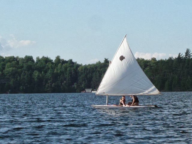
Clearly Bob
All my posts thus far have been
about hiking, climbing mountains, canoeing and kayaking in the Lake Clear area.
But I'm leaving out one of my other outdoor activity loves - sailing.
And Lake Clear is a excellent little sailing lake.
Once,
when we took one of our short road walks over to the public beach
we talked to a guy who was rigging his windsurfer on the beach. It
was a nice breezy day. He lived in Lake Placid and told us that when he
wants a real good day of sailing he either heads for Lake Champlain or Lake Clear. The two lakes could
not be more different in terms of size
but, to him, they were of comparable appeal for windsurfing. Other nearby lakes are larger than Lake Clear
but they have narrow sections, islands,
and/or bays that, although such features make for an interesting paddle, are not very conducive to
good sailing.
Lake Clear is like a inflated "L" shaped balloon
with no islands. The wind is typically onshore at the Lodge
beach so you are off and running (well, actually beating or reaching) right off
the bat. There is no bay to beat out of or windward shore to get away
from to get the best breeze.
On top of all these attributes, none other
than Albert Einstein is known to have sailed on Lake Clear. And, relatively speaking (sorry), he was a
pretty smart guy. There is a basic boat launch at The Lodge for small
sailboats.
I have a 470 and a Sunfish that I sail off a mooring standing
in the sandy bottomed shallow water to raise the sails etc.
The 470, in
case you are not familiar with it, is a 15 foot sloop rigged Olympic
class with lots of strings to pull, a trapeze and a spinnaker. It's fast
and a lot of fun -just as long as you don't get tangled up in the
spaghetti of lines that fill the cockpit.
The Sunfish is great for taking
the younger grand kids sailing or blasting off on a screaming reach when
it is so insanely windy that most sane people would not be out sailing.
And when there is no wind there are plenty of
other things to do around Lake Clear. Maybe even just sitting by the
lake and relaxing. It's been
known to happen.
Monday, October 14, 2013
Paddle Jones Pond to Church Pond
Paddle Jones Pond to Church Pond – Clearly Bob

Here's a half day
canoe/kayak trip that includes a variety of water bodies – very small ponds,
very large (why is this not a lake?) pond, small stream, and tiny historic man
made canals. There is a beach to stop at
for a swim. You can check out an historic
camp. On top of all of these
irresistible features, it is about a 10 minute drive from the Lodge to the take
out. There are no portages however, this is an “A” to “B” trip so you will need
two cars or a bicycle to set up a shuttle.
A map (the Adirondack Paddler's Map mentioned in a previous blog is the
best) is a good idea but you can probably find your way with my rough guide
below.
The put in is on
Jones Pond. But first leave a car or
bicycle at the take out on Church Pond.
Get there by driving north on route 30 to the Paul Smiths College
entrance where you turn right onto route 86.
You'll see the church and the parking area next to the pond on the left
very soon. Continue on 86 and take the
2nd left onto Jones Pond Road (local route 31) and
follow it about 2 ½ miles and look for the Jones Pond access sign on your
right. The paddling route follows the
shoreline of Jones Pond, which parallels the road, to the outlet at the western end. You aren't on Jones for very long unless you
want to cruise around and explore it.
The outlet is about 2 miles long and dumps you into the very large
Osgood Pond. Here there is a sandy area
where you can stretch and go for a swim.
The direct route across Osgood is basically straight down the pond's
length heading west but an interesting little side trip into the beginning of
the outlet (Osgood River) will let you check out White Pine Camp which was the
summer white house of President Calvin Coolidge. There is an oh so cute little glass enclosed
retreat on its own small island reached by an arched bridge that you've got to
see. If you're up for a much longer
paddle you can continue down the river about 3 miles before you reach the end
of navigable water and need to return.
Back on the main lake, oops, I
mean pond, go about ½ way down its length from the inlet, go around a long
point on the left (going between the point and an island) and paddle south into
a large bay. At the deepest point of the
bay, to the right of an obvious sandy boat launch spot (public), is the
entrance to the first of two very narrow man made canals. Assume an air of Sunday-going-to-church
reverence as you imagine long ago summer residents, attired more appropriately
than you are right now, rowing their
guide boats to the house of worship that marks the end of your trip. Just follow the small ponds and one more
canal until you find your car. Or
God.
Long Pond and Long Pond Mt
Another post …. Clearly
Bob

So a friend of
mine some time ago, after hearing me go on incessantly about camping trips,
decided he wanted to get into it. Being
somewhat excessive – compulsive he dived into extensive research to gear up for
his first trip. Before he knew it he had become one with his pieces of possible
equipment. He was having illusions that he had actually become the MSR
Whisperlight stove, or whatever.
Finally, he decided to consult a psychiatrist. “Doc”, he told the doc, “It's gotten really
bad. Why just recently I truly felt I
was a light weight backpacking dome tent and then a couple of minutes later I
was a large family tent. I'd go back and
forth – dome tent, family tent. It was
awful.” “Well”, said the psychiatrist,
“your problem is obvious. You're too
tense”.
Sometimes you
can't decide whether to go paddling or hiking.
Paddling, hiking. Hiking,
paddling. Don't have a breakdown.
Here's a day trip sure to be a tension tamer. Long Pond and Long Pond Mountain are a
nearby, complete backcountry experience.
But, you do have to portage about ¼ mile from the parking lot to the
pond. Which brings me, brace yourself,
to my short rant about kayaks vs canoes.
I can appreciate that kayaks are probably very comfortable, the longer
length models are fast, they don't have a lot of surface area (“windage” in
nautical terminology) that can cause them to be pushed around by a cross wind,
and are very good in those 3 to 5 foot breaking seas that are so common on
small Adirondack ponds. But there are
many, very enticing trips around here that include portages between a literal
stones throw to over a mile in
length. (I can only think of one of the
latter.) A kayak, especially a common
Tupperware type material one, is a huge pain to carry because of its
weight. There are certainly many routes
that require either no portage or only a very short one or two. But you're going to miss out many
others. That said, you can still lug your kayak over the portage
trail (almost all are in very good shape so using wheels may mitigate the pain)
or, for a better option, rent a light
weight canoe for the day from a local outfitter. (St Regis Canoe Outfitters in
Saranac Lake and on Floodwood Road at Floodwood Pond or Mac's right in Lake
Clear.)
To get to the
parking lot drive south on route 30 from the Lodge. The road goes
though a golf course and, shortly thereafter, make a right turn onto
Floodwood Road. There is a St Regis
Canoe Outfitters sign there also. (I'm
told by my golfing couple friends that the Saranac Inn golf course is a very
good one. To me it looks - well, simply very green.) Stay on Floodwood Road for quite a
while. You'll pass several ponds along
the way which will be mentioned in a future blog post. Just past the railroad tracks (the same
tracks that go past the Lodge) is the Outfitters shop – get your map! About 1 mile past SRCO look for a turn off to
the right and a NYS Department of Environmental Conservation (DEC) sign for
Long Pond. The good portage trail heads
down to the pond. Long Pond has a lot
of good, well spaced campsites. We've camped there many times. I remember on one trip watching a loon take
off from the water. It is the one and
only time I've seen one in flight. It
took a very long runway for the loon to finally get in the air. I've read that what makes the loon a good
diver makes it not such a good
flier. There are some sandy beaches for
a post climb swim if you want. Paddle
down the length of the pond and pass through a narrower section after which the
water is much wider. Turn left and
continue to a very narrow gap. After
passing through the gap turn to the right, paddle toward the far shore and look
for the rectangular white “portage to Mountain Pond” on a tree. Don't worry, you don't have to portage
again.
 This marks the
beginning of the trail up Long Pond Mountain.
Stash your canoe away from where others may need to get off or on the
water. In 0.6 miles the trail brings you
to Mountain Pond where you can be thankful you didn't have to carry even your
light weight canoe this far. The top is
about a mile further and, since after all it is a mountain, there are some
steep sections to the trail. There is a
rock with good views of Long Pond and many others. Enjoy your lunch. I'd recommend the free range, organic,
natural chicken sandwich on wholegrain brick oven baked homemade with love
bread. Imported from China.
This marks the
beginning of the trail up Long Pond Mountain.
Stash your canoe away from where others may need to get off or on the
water. In 0.6 miles the trail brings you
to Mountain Pond where you can be thankful you didn't have to carry even your
light weight canoe this far. The top is
about a mile further and, since after all it is a mountain, there are some
steep sections to the trail. There is a
rock with good views of Long Pond and many others. Enjoy your lunch. I'd recommend the free range, organic,
natural chicken sandwich on wholegrain brick oven baked homemade with love
bread. Imported from China. Climbing St Regis Mountain, NY

My name is Bob and I am a neighbor of the Lodge on Lake Clear.
I'm very enthusiastic about the multitude of outdoor opportunities available in the Lake Clear area.
I want to enlighten potential visitors to hiking, climbing, canoeing/kayaking, snowshoeing and cross country skiing day trips that are easily accessed from here.
For my first trip I'll pick the most obvious - St Regis Mt. I say most obvious because St Regis is the mountain that dominates the view from The Lodge beach.
I've climbed St Regis more than any other mountain - probably around 60 times including in the winter. ( Actually a favorite little cross country ski jaunt is skiing up the St Regis trail until the steeper section starts. But that's for another post.)
There is a great view from the top of St Regis Mountain - of the numerous lakes that start right at the mountain's base and extend far off into the distance. Lake Clear is right there front and center. The high peaks are visible too but they are pretty far away. One year we climbed St Regis, pitched a small tent on the one flat grassy spot, and stayed up there overnight so we could stay up late and watch the Perseid meteor shower. Then we woke up early and watched the sun rise over the lakes. Pretty cool ! So far we've gotten 3 of the 7 grand children to the top using their own leg power.
To get to the trail head : take a left out of the Lake Clear Lodge main driveway, then take the next left up Route 30 North. Drive north on route 30 to Paul Smiths College, about 5-6 miles. You'll see the main college entrance on your left (you would turn right to go to Saranac Lake from here). Immediately past the entrance turn left on Keeses Mills Road. Go about 2.5 miles and you'll see a small parking lot on the right with a Visitor Interpretive Center (VIC) sign. About another 100 yards down the road is a large gravel parking lot on the left which is where you park. Walk down the dirt road by the parking lot about 1/10th mile to where the actual trail begins.
Distance is 3.4 miles each way with a 1266 foot climb. It's certainly not easy but not too difficult a climb either.
Of course all such pronouncements are highly subjective ! Have fun!
Kid friendly hikes and climbs near Lake Clear in the Adirondacks

Kid friendly hikes and climbs near Lake Clear in the Adirondacks
OK, I did mention grand kid friendly places above so here a few easy mountain climbs for the young ones. I think you'll enjoy them too and it's certainly better than trying to cajole a reluctant budding hiker up too challenging a peak. It is so much fun to be part of a child's first climbing experiences, even if he or she needs a little help from a grown up.
Right in the village of Saranac Lake is Baker Mountain. It's a short (0.9 mile), in places a bit steep, climb to the summit where there are good views of Mc Kenzie Pond and Mc Kenzie, Haystack and Moose Mountains one way and, if you stop on one of the several rocky ledges off to the right before the actual summit, views of the village and lakes. To get to the trail head turn left at the second traffic light coming into town from Lake Clear onto route 3, then right onto Pine Street just past the Belvedere Restaurant, then left onto East Pine St (the 2nd left). Follow the road around to the far end of Moody Pond. Park on the right next to the pond. The trail starts on the left side of the road.
A longer drive (about 40 minutes) brings you to Coney Mountain south of Tupper Lake. It has a somewhat better 360 degree view from the treeless summit compared to Baker with Tupper Lake prominently featured. The kids will enjoy picking blueberries at the top. (OK, admittedly I do too.) It's about 1 mile up an easy trail. Bring lunch and enjoy a picnic with a view. Get there by following route 30 south through the village of Tupper Lake – 30 makes a left turn in the heart of downtown TL. About 5 miles south of town there is a parking turn off on the right just past the Hamilton county boundary sign. The trail head is on the opposite side of the road about 200 feet closer to Tupper. There is an Dept of Environmental Conservation trail sign in the grass back from the road marking it.
Panther Mountain rounds out this trio of family climbs. It offers a 0.7 mile climb to a partially bare summit with views of far off Tupper Lake and some closer high peaks. The views from Baker and Coney are better in my opinion. To get there drive south on route 30 to the “T” intersection with route 3. Turn left on 3 heading toward Saranac Lake, go 1.6 miles and look for the parking lot on the right. The trail head is on the opposite side of the road .
These 3 are the easiest mountains in the area. We've climbed them all numerous times with grand children of all ages admittedly including some carrying of the youngest ones at times. Eventually I suppose the appeal will be they are easy enough for my old, aching body to summit ! But not too soon for that scenario – I'm 2 climbs away from finishing my 2nd round of climbing the 46 Adirondack high peaks.
Stay near us and book a room at The Lake Clear Lodge where they offer a main Lodge plus suites and chalets on 25 acres
Gentle hikes near and around Lake Clear, NY

Sometimes you just want to go for a nice walk in the woods - not a commando assault on Mt Huge.
There are lots of options in this category. I'll start by describing a trio of nearby routes we frequent off route 30 heading north from the Lodge. (Obviously you can just stroll on the considerable acres of the Lodge property or walk forever on the railroad tracks. With regard to the latter, watch out for the passing train engine. It goes by twice a year at the blazing speed of about 3 MPH accompanied by a loud clanging bell !)
The most popular place to walk around is the nearby Visitor Interpretive Center run by Paul Smiths College. There is good reason for its popularity. The many trails are well maintained, foot friendly smooth, and offer a variety of ecosystem experiences. Some of the trails feature long boardwalks across boggy areas. There is a very large blown down tree at the end of one of these boardwalks where the pulled up root system impressively towers over your head. It's probably 20 feet tall. Next to the VIC building is a small playground for the kids and a butterfly house with a helpful staff person to answer your questions. The VIC is not exactly a wilderness experience but, if it is the goal, you can hike for a long time on the numerous trails. And you may learn something. Plus, it's free. It is located about a mile past the Paul Smiths entrance, which itself is about 6 miles north on route 30 from the Lodge.
Black and Long Ponds offer nice water side walks. Naturally, Black Pond is longer than Long Pond. I haven't yet done an analysis of their relative blackness. (You have to wonder about the naming of ponds around here. Within 4 miles there are 3 Green Ponds. Well, actually one is Little Green Pond which, of course, is larger than one of the Greens and of similar size to the other.) The trails mostly course along side the water with mild ups and downs. At the end of Black Pond you can turn right, cross the fish barrier dam and do a circumnavigation of the pond. There is a bridge over the short connection between Black and it's smaller polyp like bay to the east which is a nice place to sit and enjoy a snack in the sunshine. If you go straight instead of crossing the dam the trail goes to a leanto near the far end of Long Pond. Go out on the dock in front of the leanto. The trail continues past the leanto and connects to the Jenkins Mountain trail, but that's another story. You have to backtrack along Long to the junction by the fish barrier dam. If you walk around Black there is a steep 1 to 2 minute climb near the end. After this short pitch look for a long sloping rock on the right which looks down on the smaller channel before it opens up to the pond. We once saw a loon swimming rapidly underwater here from our high up vantage point. It was quite a memorable experience. Access the ponds by turning left on Keese Mills Road immediately past the Paul Smith entrance. Drive about 2 ½ miles to a small, wood rail enclosed, dirt parking area on the right with a VIC sign. There is a map at the trail sign in kiosk. Though this area is part of the VIC it is far away from the main VIC trails.
Another Paul Smiths group of trails is called the Red Dot Trails. It's a bit of a maze so I can't describe any specific routes. Just bring a sense of adventure and you'll eventually end up someplace familiar since the trails loop around. In the process of exploration the trails you walk along Church, Little Church and Osgood Ponds and cross a couple of man made canals that connect the ponds. These water passages were dug so people could get to church without portaging their guideboats. Find the Red Dot Trails by turning right into the roadside parking area opposite Keese Mills Road and then continue slightly further away from the road though the woods to the white church. The trail starts on the left side (as you drive in) of the parking area in front of the church. Park by the church.
Subscribe to:
Comments (Atom)